Urban Renewal and Equity: The Decline and Resurgence of New York City Ferries

Olivia Rubano

Ferries are historic to New York City. The city is interwoven in water, and throughout the 19th and early 20th centuries, ferries were a logical mechanism of transportation (Glowinski). Over the past century, New York City’s ferries have peaked and then declined due to urban renewal (Glowinski). Ferries have become more popular in New York City in recent years (Mcgeehan). Their resurgence has made apparent their changed relationship with the city due to urban renewal and the rise of subways and has presented issues of accessibility and equity because of the location of their stops and their fare.

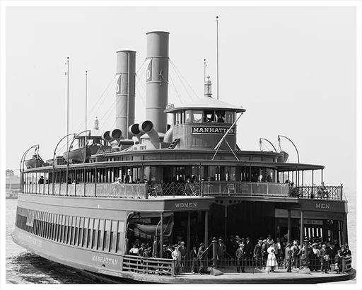
A New York City ferry in the 1920’s (Old NYC Photos).

In 1904, 147 ferry boats were in operation, and in 1905, the city took control of the ferry system (Glowinski). The system went through a period of growth from 1918-1925 due to new boats, new boat designs, and devising new ferry routes (Glowinski). When the stock market crashed in 1929, the New York ferry system began to decline (Glowinski). There was suddenly less revenue and, thus, less available money to spend on ferries (Glowinski). However, the available funds went toward automobile infrastructure (Glowinski). Through the 1960s, New York City underwent rapid urban renewal, and ferry routes were replaced by bridges and tunnels (Glowinski). Operating from 1920 to 1936, the ferry route between 92nd Street and Astoria was replaced by the Triborough bridge, an urban renewal project spearheaded by Robert Moses, New York’s “larger-than-life administrator who headed the most important state and city redevelopment agencies in New York City from the 1930s to the 1960s” (Glowinski; Zukin 13; NYPAP). The Class Point to College Point ferry route ran from 1921 to 1939 until the Bronx-Whitestone Bridge was constructed, another project lead by Robert Moses (Glowinski; NYPAP). Beyond these two bridges, many of Moses other projects, like parkways and highways, opened the city up to cars, leading to the decline of ferries.

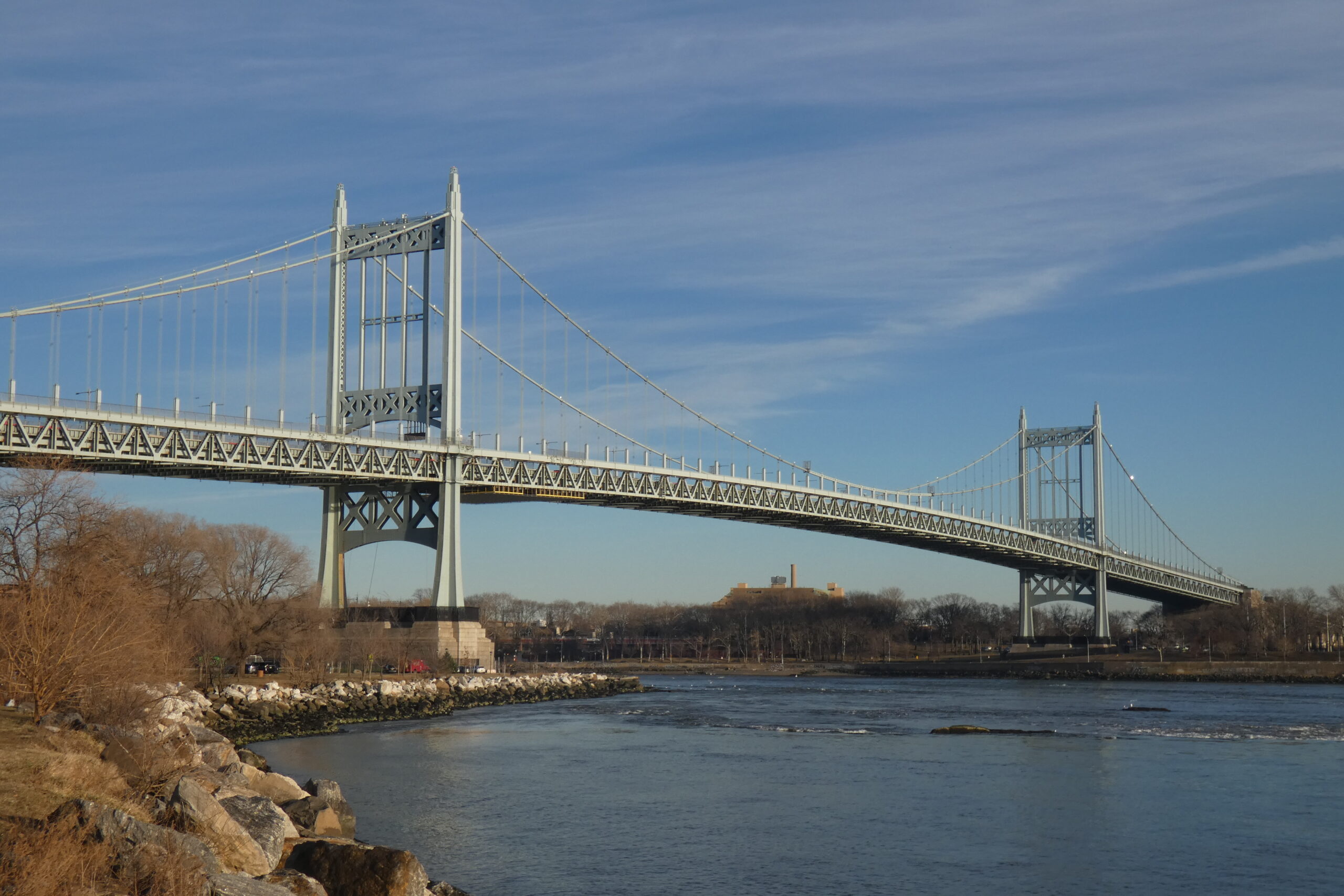
The Triborough Bridge, built in 1936, which opened the city up to automobiles (Wikipedia).

Ferries serve as an echo of a New York city before increased automobile infrastructure and Robert Moses, and in recent years, there has been a resurgence in New York City ferries due to their low fare of $2.75 and overall charm compared to the “beleaguered subway system” (Mcgeehan). On April 28th, the ferry system reached one million riders in the first thirteen weeks of 2023 (NYCEDC). Thirteen weeks is the earliest that the New York City Economic Development Corporation and NYC Ferry has ever recorded reaching this many riders (NYCEDC). This resurgence has not come without its issues. In 2017, demand for ferries outstripped supply (Goodman and Mcgeehan). Crowds were showing up to board, and there was not enough room to fit all the passengers (NYT). The city had to charter more boats, larger boats, but that takes time (Goodman and Mcgeehan). A spokesman for City Hall, Wiley Norvell, explained that, “Some of this is going to be trial and error. We’re not the subway. We don’t have 70 years of detailed ridership telling us how many trains to run after a Yankee game” (Goodman and Mcgeehan). Despite ferries being historically intertwined with the city, the decline set on by urban renewal has disrupted this relationship, introducing unknowns.

Additionally, because of the rise of subway systems, ferries are not always perceived as convenient; ferries often have 30-minute intervals between departures whereas their rival transportation has mere minutes (Kahn; NYC FERRY “New York NYC Ferry Routes & Schedules”). Ferries serve those who have the luxury of time. Millions of people in New York City take the subway everyday; one million people took the ferries over three months (Mcgeehan). Despite their come back in recent years, ferries are no longer a vital organism of the city, and rivers do not serve as “natural roads” in the same way they did in the 19th and 20th centuries (Glowinski).

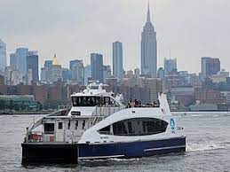
A New York City ferry in front of the Empire State Building (Wikipedia).

Moreover, ferries are not equally accessible to everyone, but with new government efforts, there is opportunity for the city to address these issues. In 2019, twelve of NYC’s nineteen stops were in areas where per-capita annual incomes exceeded the city’s average; seven of those stops had per-capita annual incomes that were twice the city’s average (Hicks). The ferry was most accessible to wealthier people. In 2022, the Mayor Eric Adam’s proposed the Ferry Forward plan. The goals of this plan are to make the ferry system more equitable, accessible, and financially sustainable (NYC Ferry “Cruising towards Another Record-Setting Year”). Cortney Worrall, CEO of Waterfront Alliance, which protects New York/New Jersey Harbor, thinks that with this plan, “There is great opportunity to expand services to new locations, to identify transit deserts that would be well-served by ferries” (City of New York; Waterfront Alliance). In order to make ferries equitable, ferry stops need to be located in a variety of communities, not just wealthy ones.

Beyond ferry stops, ferry fares also present issues of equity. The New York City ferry system does not generate enough revenue to cover operation costs, and a significant cost burden falls on tax payers (Meyer and Hicks). Typically, those riding the ferries are wealthier, having median annual incomes of $100,000-150,000 (Meyer and Hicks). These typical riders will be able to supply an increase in fare, and in the Ferry Forward plan, Mayor Eric Adams raised the one way rate from $2.75 to $4.00 (Meyer and Hicks). If only this action was taken, predominantly wealthy ridership would likely be perpetuated because lower income riders may seek cheaper alternatives to ferries like the subway (Meyer and Hicks; MTA “Riding the Subway”). However, Mayor Adam’s Ferry Forward plan does work to address income disparities and equity, offering seniors and ferry riders with lower incomes and disabilities the discounted rider rate of $1.35 (City of New York). The Ferry Forward Plan was released in July of 2022, and ridership has increased in 2023 (NYCEDC). In order to determine if ridership increased because of discounted fares aimed to make ferries more equitable, new data must be collected and should be announced to the public. 

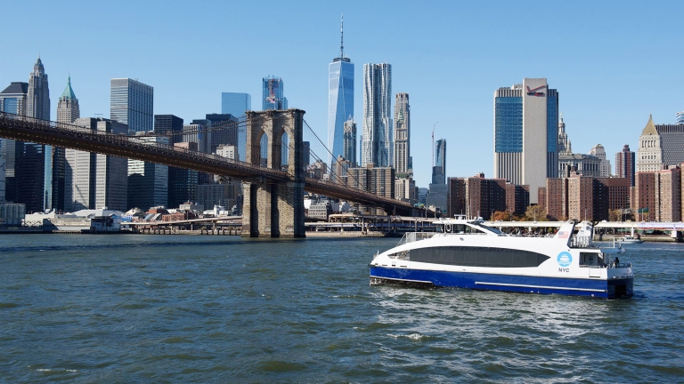
A New York City ferry journey near the Brooklyn Bridge (NYCEDC).

It is essential that people are not further isolated from the waterways that intersect New York City. In 1936, Robert Moses built the Henry Hudson Bridge, destroying residential areas and green spaces along the Harlem River (Carr; Gray; MTA “Henry Hudson Bridge”). More recently, clean up efforts have caused the Hudson River’s banks to be the site of gentrification, pushing out existing communities (Turrin). To truly restore ferries as a mode of transportation within the city, it is critical to consider whether ferries are truly ingrained in New York City as a whole or if they serve as an embellishment for those who are privileged enough to partake.

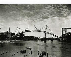
The construction of the Henry Hudson Bridge (Wikipedia).

Sources

Carr, Ethan. “The Hudson River Waterfront: Recollections and Observations.” SiteLINES: A Journal of Place 3, no. 2 (2008): 8–11. http://www.jstor.org/stable/24889304.

City of New York. “Mayor Adams Unveils Phase One Of.” The official website of the City of New York, July 14, 2022. https://www.nyc.gov/office-of-the-mayor/news/505-22/mayor-adams-phase-one-nyc-ferry-forward-vision-more-equitable-accessible-#/0.

Glowinski, Patricia. “The Rise, Fall, and Rise Again of the New York City Municipal Ferry System.” NYC Department of Records & Information Services, October 9, 2019. https://www.archives.nyc/blog/2019/7/29/ferries.

Goodman, J. David, and Patrick Mcgeehan. “NYC Ferry, More Popular than Expected, Scrambles to Meet Demand.” The New York Times, June 15, 2017. https://www.nytimes.com/2017/06/15/nyregion/nyc-ferry-more-popular-than-expected-scrambles-to-meet-demand.html.

Gray, Christopher. “Streetscapes/Henry Hudson Bridge; a Controversial ’36 Span through Dreamy Isolation.” The New York Times, August 10, 2003. https://www.nytimes.com/2003/08/10/realestate/streetscapes-henry-hudson-bridge-controversial-36-span-through-dreamy-isolation.html.

Hicks, Nolan. “City Ferry Mostly Benefits the Wealthiest New Yorkers.” New York Post, April 1, 2019. https://nypost.com/2019/03/31/city-ferry-mostly-benefits-the-wealthiest-new-yorkers/.

Kahn, Sonia. “What Goes up Must Come down: A Brief History of New York City’s Elevated Rail and Subway Lines: Worlds Revealed.” The Library of Congress, May 19, 2022. https://blogs.loc.gov/maps/2022/05/what-goes-up-must-come-down-a-brief-history-of-new-york-citys-elevated-rail-and-subway-lines/.

Mcgeehan, Patrick. “New York City’s Ferry Fleet Is off to a Fast Start.” The New York Times, November 29, 2017. https://www.nytimes.com/2017/11/29/nyregion/new-york-ferry.html.

Meyer, David, and Nolan Hicks. “Adams Seeks NYC Ferry That Can Break Even – or at Least Not Soak Taxpayers.” New York Post, September 8, 2022. https://nypost.com/2022/09/08/nyc-seeks-guaranteed-revenue-from-its-costly-ferry-service/.

MTA. “Henry Hudson Bridge.” MTA, July 10, 2023. https://new.mta.info/bridges-and-tunnels/about/henry-hudson-bridge.

MTA. “Riding the Subway.” MTA, August 20, 2023. https://new.mta.info/guides/riding-the-subway#.

NYCEDC. “NYCEDC and NYC Ferry Announces Record Breaking Ridership Numbers.” NYCEDC, April 28, 2023. https://edc.nyc/press-release/nycedc-and-nyc-ferry-announces-record-breaking-ridership-numbers#:~:text=These new ridership numbers build,of the ridership share respectively.

NYC Ferry. “Cruising towards Another Record-Setting Year.” New York City Ferry Service, March 23, 2023. https://www.ferry.nyc/blog/cruising-towards-another-record-setting-year/#:~:text=New%20York%20City%27s%20NYC%20Ferry,with%20disabilities%2C%20and%20Fair%20Fares.

NYC FERRY. “New York NYC Ferry Routes & Schedules.” New York City Ferry Service. Accessed October 17, 2023. https://www.ferry.nyc/routes-and-schedules/.

NYPAP. “Robert Moses.” NYPAP. Accessed October 17, 2023. https://www.nypap.org/preservation-history/robert-moses/#:~:text=He was principally responsible for,Verrazano Narrows Bridge, the Westside.

Turrin, Margie. “Issues of Inequity Explored by the next Generation of Hudson River Educators.” State of the Planet, November 10, 2021. https://news.climate.columbia.edu/2021/08/29/issues-of-inequity-explored-by-the-next-generation-of-hudson-river-educators/.

Waterfront Alliance. “About Us.” Waterfront Alliance. Accessed October 17, 2023. https://waterfrontalliance.org/who-we-are/about-us/.

Zukin, Sharon. Naked City: The death and life of authentic urban places. Oxford: Oxford University Press, 2011.

Images

Ferry in front of Empire State Building. Wikipedia. Accessed October 17, 2023. https://en.wikipedia.org/wiki/NYC_Ferry.

Ferry near Brooklyn Bridge. EDC. Accessed October 17, 2023. https://edc.nyc/project/nycferry.

Henry Hudson Bridge construction. Wikipedia. Accessed October 17, 2023. https://en.wikipedia.org/wiki/Henry_Hudson_Bridge.

Triborough Bridge. Wikipedia. Accessed October 17, 2023. https://en.wikipedia.org/wiki/Robert_F._Kennedy_Bridge.

1920s Ferry. Old NYC Photos. Accessed October 17, 2023. https://oldnycphotos.com/products/manhattan-municipal-ferry-new-york-n-y-1920.

Baltimore Inner Harbor Pollutants to Potential

By Karenna Laufer

Baltimore was first developed as a trade center with the harbor serving as a major port. Founded in 1729, the city’s location is uniquely nestled alongside a vast wheat growing countryside, closer to rich farmland than Philadelphia. With increasing industrial opportunity, immigrants flocked to Baltimore, entering through the harbor and scrambling for housing in the city center. The harbor has always played a key role in the city’s economy as well as civilian’s lives.

Mock-up image of Baltimore during the 18th century; the city’s focus concentrated around the harbor.

Today, the city looks much different. While much of Baltimore faces poverty levels and battles gentrification, the harbor is also incredibly polluted. In the early 19th century, the tidal marshes were dredged out and replaced with deep-water shipping ports, aquatic life removed (Shwe). By the mid-20th century, “much of [Baltimore] was set for demolition” as most of the city was “viewed by city leadership as a waterfront slum…deemed better to pave than preserve” (Cassie). Growing up, I was told stories of dolphins that could be seen swimming in the harbor hundreds of years ago. Currently however, the water is nearly opaque. It is illegal to swim in the water due to high pollutant levels; Baltimoreans risk chemical burns if they enter. Physical trash can be seen sitting on the water’s surface. While several initiatives have been implemented and promises made, bacteria levels remain high. The major pollutant in the water run-off and sewage leaks from wastewater treatment plants (Wheeler).

Visible pollution sitting upon the harbor’s surface.

With the harbor failing to be the attraction it could be, the waterway is largely only used for industrial purposes. The area does not serve as the gathering place it has the potential to be. Much of the waterfront areas consist of large factories including the massive Under Armour factory and headquarters. Furthermore, the city’s waterfront property not being used as factory space is becoming vacant: “With the two Harborplace buildings at the heart of the tourist waterfront more than 90% vacant, there is little for visitors to do but enjoy the view and keep on walking” (Shen).

However, this area has so much more potential. The harbor could serve as a community gathering place, hosting an assortment of recreational water activities such as kayaking, fishing, and even swimming. Architects push to put the water at the forefront of the city, making harbor-side buildings “architecturally transparent” to showcase the natural beauty of the environment (Swift). While some urban planners advocate for increasing waterfront retail and communal buildings, other advocate for tearing down and not rebuilding. With an issue in vacancy of downtown complexes, a solution could be the transformation of the Inner Harbor into a beach. Nothing drives communal gathering like a beach. This proposal could jumpstart rapid initiatives to clean the harbor all around benefitting the community and environment.

One vision of what the city center could look like if the water were to be cleaned. The area could serve as a communal beach area where residents gather and foster community.

Currently, the National Aquarium, which ironically sits adjacent to the polluted harbor, has proposed the re-creation of original tidal marshes by building an oasis of floating wetlands open to the public. They have already taken steps towards this vision launching a pilot project. This would act as a “low-tech green infrastructure” used to clean air and water (Shwe) . The National Aquarium plans to expand its current pilot project to a network of floating wetlands with piers connecting for visitors to traverse.

The National Aquarium’s current vision for the addition of wetlands back into the harbor. Community members gather and partake in activities such as kayaking. Nature flourishes with aquatic life and other critters returning to the harbor.

With more initiatives leading to increasing awareness about the harbor, many are hoping to motivate people to be more conscious of the harbor pollution. The harbor has the opportunity to be the center of the community, the living room of the city, yet it is not being showcased to its full potential. Gradually, some change has been implemented as Baltimore begins to see progress in water pollution levels. New urban planning designs appear to be sparking these cleaning initiatives, as Baltimoreans begin to see the potential for the communal living a clean harbor would provide, benefiting both city dwellers and the environment simultaneously. 

Works Cited

Cassie, Ron. “The Gritty History (and Gentrification) of Fells Point.” Baltimore Magazine, 10 July 2023, www.baltimoremagazine.com/section/historypolitics/fells-point-baltimore-250-year-history-grit-gentrification/.

Shen, Fern. “Harborplace Now: Empty Shops, Locked Doors and a Fabulous View.” Baltimore Brew, 20 Apr. 2023, www.baltimorebrew.com/2023/04/20/harborplace-now-empty-shops-locked-doors-and-a-fabulous-view/.

Shwe, Elizabeth. “Floating Wetlands Planned for Inner Harbor to Revive Urban Ecosystems, Clean Water.” Maryland Matters, 16 Jan. 2022, www.marylandmatters.org/2021/09/09/floating-wetlands-planned-for-inner-harbor-to-revive-urban-ecosystems-clean-water/.

Swift, Tim. “Extreme Makeover Inner Harbor Edition: Five Ways to Reimagine Harborplace.” WBFF, 9 Apr. 2022, foxbaltimore.com/news/local/five-ways-to-reimagine-harborplace-extreme-makeover-inner-harbor-david-bramble.

Wheeler, Timothy B., and Dave Harp. “Swimming and Fishing Safely in the Baltimore Harbor? Not so Fast.” Bay Journal, 25 Sept. 2020, www.bayjournal.com/news/pollution/swimming-and-fishing-safely-in-the-baltimore-harbor-not-so-fast/article_920826c8-ff67-11ea-a31b-830821c9cb4f.html.

Value of an Unused but Aesthetic Space

By Colin Doyle

In my hometown of Downers Grove, Illinois, there’s a a major East-West street that’s close to the downtown called Prairie Avenue. People in the area know Prairie as one of the best ways to get between the three major North-South streets, those being Highland, Main Street, and Belmont. On that street, up until December of 2021, there was a lot with an old school and even older oak trees scattered throughout the lot. Most people who wanted to go west from the train station at Belmont traveled down Prairie, and passed the old school. For me, it was a visually distinct landmark that divided Prairie Avenue in half. The old school was called Longfellow.

Longfellow, the former elementary school
Front Side of Longfellow. Photo Credit of Daily Herald

What was formerly Longfellow school is currently Longfellow On Prairie, a housing development being led by McNaughton Development. At the end of 2021, the property was sold after a period of brief resistance from the local homeowners, especially those who lived on the two streets that flanked the school. They, alongside some other residents in the neighborhood, argued that Longfellow was a historic building, and resorted to heroic and effective manners of protest such as planting lawn signs with the #savelongfellow hashtag and complaining on line. Sarcasm aside, I do think that the who debacle raised an interesting question about the value of an aesthetic place even if its current value is much less than it proposed value.

The current state of Longfellow. Photo credit of Fiona Doyle, the team’s on-site reporter in Downers Grove

Prior to its demolition, Longfellow wasn’t actually being used as a school. The school was built in 1928, but in the 1980s it ceased its use as an elementary school and was converted into office and storage space for the district 58 school district. This was likely due to its proximity to two other elementary schools within half a mile, which made its central location redundant.

The district stated that it was becoming too expensive to maintain the nearly century old building, and the $4.1 million the lot sold for probably sweetened the deal. It was an understandable financial decision. The significant sum of money can go into better funding for the schools, and it’s obviously very difficult to argue against bettering schools for children. But I wonder if there’s something intangible that’s lost in moves like this. Downers Grove and other towns like it have become hot within the last 10 or so years. Its affluent north portion contains both a growing downtown and a train line that leads into Chicago, so apartments and housing are rapidly popping up for the people who want to work in but not necessarily live in the city. Thus, property values are increasing which in turn increases school funds. The school district likely wanted to strike while the iron was hot, but it’s not like the area was in a dire financial situation either. The sale of the Longfellow lot wasn’t the catalyst; fancy new homes had been popping up in the neighborhood for a while.

The Longfellow lot as seen from above. The property had numerous old oak trees. Photo credit of Daily Herald

The question of the aesthetic and emotional value of a place is hard to answer. Maybe I’m just arguing from the illogical, knee-jerk perspective of a college student who came back from New York one year and was shocked to see an iconic aspect of his neighborhood changed. But as I see an increasing number of eerily similar large houses that squeeze as much square footage out of their lots without trying to preserve the trees or the original feel of the lot, I become a little dismayed. I worry that often times suburban development happens rapidly and in a very homogenized manner, which destroys the uniqueness of a place and detracts from the identity of the community.

Sources used :

https://www.dailyherald.com/news/20220217/fight-over-longfellow-center-property-prompts-downers-grove-to-revise-zoning-rules
https://www.dailyherald.com/news/20210923/downers-grove-residents-seek-historic-designation-to-former-school
https://mcnaughtondevelopment.com/longfellow/
https://www.shawlocal.com/my-suburban-life/news/downers-grove/2021/10/01/housing-developer-to-buy-93-year-old-longfellow-center-in-downers-grove/

Once disaster disrupts the practice of place, are you ever able to get it back?

Gainsley Korengold

New Orleans is often hailed as the soul of America, celebrated for its distinctive art and culture. The individuals born and raised in New Orleans share an intrinsic connection to its people, places, and traditions. However, the devastating impact of Hurricane Katrina in 2005 left much of the city, particularly in predominantly African American communities, in ruins. The question lingers: can the practice of place and the deep-rooted connection to the city ever be fully restored?

Hurricane Katrina disproportionately affected black homeowners in New Orleans, with more than three times the likelihood of flooding compared to their white counterparts. This deliberate and political outcome stemmed from racially discriminatory housing practices and city planning. Despite extensive efforts to rebuild and reconcile with the pain inflicted on the city, we must question for whom the city is undergoing reconstruction.

A family sits on their porch in the Treme area of New Orleans, known to be one of the oldest African American neighborhoods in America. (Bloomberg)

When Hurricane Katrina hit, the flooding disproportionately harmed black neighborhoods, exacerbating racial and social inequality. Pre-Katrina, African American culture thrived. Now, 96,000 fewer African Americans are living in New Orleans, than prior to Hurricane Katrina. Nearly 1 in 3 black residents have not returned to the city.

Having personally experienced Hurricane Katrina’s impact, I relocated from New Orleans to New York, and my parents lived in New Orleans for ten years prior. Our evacuation entailed losses and a prolonged sense of displacement. But, 18 years later, when we visit the area I was born, it looks familiar and comparable to how we left it. This is because parts of the city have been rebuilt to closely resemble pre-Katrina New Orleans, including Uptown and the Garden District, close to where I used to live. And, these are the areas that were least effected by the storm in the first place. It’s no surprise that the recovered areas are predominantly white.

Image of Camellia Grill (Wikipedia), which opened in 1946, closed during the storm, and reopened again afterwards. A staple for both locals and tourists alike, Camellia Grill serves as a gathering place that brings together people from all areas of the city. In my opinion, Camellia Grill serves as one of the few pre and post-Katrina cultural landmarks that has been able to maintain its place in the city.

In speaking with my father, Michael Korengold, he described New Orleanian culture as “a caricature of what is once was,” a false display set up for tourists to experience pre-Katrina culture. When discussing the rebuilding of the city after the storm, he said, “Once Katrina hit, you had a lot of people coming from different organizations to help with the rebuild, and a lot of those people chose to stay. Those people brought with them no cultural background from New Orleans’ history, and many of the people that were responsible for the traditions were gone. This leaves you with many people who adopted their best estimation of New Orleanian culture. There were those who were grateful for the help in rebuilding the city and for choosing to live there during a difficult time. But the flip side is that many of those people were outsiders and unlikely to ever change their outsider status.”

The focus needs to shift to the underlying question of who is truly benefiting from the city’s reconstruction. In areas like the Seventh Ward, a predominantly black working-class community, the recovery is far from complete, and the practice of place remains incomplete for many black Americans. The essence of New Orleans lies in its people and their connection to the city. Once this connection is severed, the heart and soul of New Orleans are compromised, breeding resentment, and depleting the city of its unique culture.

Now, what used to be authentic New Orleanian culture has turned into a point of money-making to bring in tourists, to the point where New Orleans natives feel as though they’re performing their culture for outsiders, rather than living it for themselves like they used to.

The ongoing challenge is whether New Orleans can fully reclaim its unique cultural explosion across the entire city. While certain areas, like the French Quarter, may offer a semblance of New Orleanian culture for tourists, full restoration of the city’s practice of place is critical to resurrecting pre-Katrina New Orleans. Until this overarching recovery is achieved, the city will remain an imitation of its former self, lacking the genuine spirit of the people that define its cultural richness.

https://www.urban.org/research/publication/rebuilding-cultural-vitality-new-orleans

https://talkpoverty.org/2016/08/29/white-new-orleans-recovered-hurricane-katrina-black-new-orleans-not/index.html

https://www.newyorker.com/books/under-review/why-hurricane-katrina-was-not-a-natural-disaster

https://en.wikipedia.org/wiki/Camellia_Grill

https://www.bloomberg.com/news/articles/2015-08-25/8-maps-of-displacement-and-return-in-new-orleans-after-katrina

Florence as a Place for Tourists and Locals

By Catherine Vogt

Florence, Italy: home to the birth of the Renaissance with the Cathedral of Santa Maria del Fiore, Michaleganelo’s Statue of David, and Boticelli’s The Birth of Venus. Moreover, being located in the center of Tuscany, Florence boasts a menu of delicious cuisines, such as pappardelle cinghiale, bistecca alla fiorentina, and ribollita. However, with tremendous works of art along with exquisite food comes an extraordinary number of tourists flooding the streets of the Tuscan capital.

A crowded Palazzo Vecchio. Photo courtesy of Marcus Lindstorm of Getty Images.

Since the easing of COVID-19 travel restrictions, Florence has experienced a sharp increase in tourists. Just in the summer of 2022, Florence saw 198 million tourists stay overnight in the city, a 15.5% growth from the previous summer. The vast majority of tourists come from the United States, Germany, Spain, and France who strengthen Florence’s economy bringing in an average of €3 billion a year.

 Carlo Francini, the head of the United Nations Educational, Scientific and Cultural Organization (UNESCO) office of the City of Florence, noted that because Florence is a UNESCO World Heritage site, the city must be open to all. In the wake of increasing numbers of foreigners visiting the city though, the city issued guidelines on how to properly behave, such as not lying on church steps, littering, and respecting local vendors. Despite the very public guidelines throughout the city, some tourists are still disrespectful. For example, a tourist recently damaged the 16th century Fountain of Neptune while trying to take a selfie with the sculpture.

Guideline image on how to behave in front of churches. Courtesy of Enjoy Respect Firenze.

In addition to issuing behavior guidelines, Florence has taken further steps to combat unruly tourists. Currently, Florence has 11,000 short-term private rental properties with 8,000 of them within the historic center, which is a UNESCO World Heritage Site. However, this past June, Dario Nardella, the mayor of Florence, announced that the city had banned future Airbnbs and short-term rentals. The Italian city is also offering tax incentives for Airbnb and short-term rentals owners who convert their properties into long-term rentals. Florence’s plan not only seeks to prevent overcrowding from tourism, but it also works to address the affordable housing shortage in the city by providing more housing options for students and locals.

Even though Florence is a tourist hotspot, the city is home to approximately 710,944 locals. Most locals live in more residential neighborhoods typically 30 minutes outside the centro storico (historical center), which is significantly cheaper and less crowded. When I studied abroad in Florence, my program organized dinners where my fellow students and I could dine with local Florentine families. During my meal with a family of four, they expressed frustration when it came to overcrowding during Florence’s busier periods, specifically around Easter and between May and August. The family did acknowledge the economic benefit of tourists as the wife had been working as tour guide for over 20 years and the husband worked in the real estate industry. 

The Piazza del Duomo (left) and Via dei Calzaiuoli (right) on Easter. Photo Courtesy of Catherine Vogt.

While I had a positive experience with the local Florentine family, some of my peers did not. One of my roommates was very confused in the grocery store and asked a local for help. The Florentine local responded with a harsh “Americani!” followed by Italian words my roommate did not understand, but they were definitely not kind. 

There is no uniform sentiment on tourists from a local Florentine’s perspective, but it is clear that tourism plays a crucial role in the day-to-day operations of the Italian city. It is hard to imagine a Florence that does not attract tourists; however, with stricter guidelines and restrictions to prevent overcrowding and ill-mannered tourists, it is possible to give the city of Florence back to the local Florentines.

Bibliography

Destination Florence. “Tourism in Florence: tour operators give their take.” October 12, 2022. https://www.theflorentine.net/2022/10/12/tourism-florence-tour-operators/.

“Florence Tourism Statistics 2023.” GoWithGuide. January 27, 2023. https://gowithguide.com/blog/florence-tourism-statistics-2023-5219.

Korey, Alexandra. “Italy vs. the Tourists.” The Florentine. September 12, 2017. https://www.theflorentine.net/2017/09/12/italy-tourists/.

Parker, Benjamin. “Italian city bans Airbnbs in its historic centre.” The Independent. June 2, 2023. https://www.independent.co.uk/travel/news-and-advice/florence-italy-airbnb-rentals-ban-b2350210.html.

Zitser, Joshua. “A man damaged a 16th-century Florence fountain while climbing it for a selfie, the latest example of tourists wrecking things.” Business Insider. September 5, 2023.  https://www.insider.com/german-tourist-damages-florence-italy-monument-fountain-neptune-taking-selfie-2023-9.

Gateways and Their Places

By Jonathan Nemetz

Places would not exist without the boundaries that mark their end. However, all boundaries are, to some extent, permeable. It is movement between places that gives their differences meaning, and allows different places to be strung together into routines and mental maps. The gateway is a concept as essential to place as a door is to a home, and can say just as much about the places it facilitates movement between. Gateways can be grand or hidden, controlled checkpoints or merely mental, but their powers of delineation are of vital importance to the study of place. 

Intentional gateways can be designed specifically to reflect the place that they are welcoming people into. One of the most evocative examples of this is a ‘Chinatown’ Gate featured in many American cities. These gates act as unmissable wayfinding, breaking up the homogeneity of many contemporary American cities. They are also a statement about the values and expectations of the place behind the red gates. The bold architecture builds a sense of pride and belonging in the residents of a neighborhood about the value they place in the traditions of their home countries (the architecture of such gates are often bold and over the top reimaginings of Chinese design). For visitors, the gates provide a snapshot of the businesses and activities they can expect in the area, and marks a visit to the area as something special and distinct from the rest of the city. These gates help build a unique identity and sense of place within the wider fabric of a city, and act as much like a part of the place as a vestibule for it. 

The gate into the Chinatown area of Los Angeles, featuring more apocryphal architecture within

Other gateways are far less noticeable, and sometimes unintentional. Here at Hamilton College, the nature of the split campus means that the long path stretching from the Science Hall on the ‘lightside’ to Major Hall on the ‘darkside’ gets tremendous traffic everyday. This one path connecting people across Martin’s Way is full of gateways for different people. The gatehouse feel of Beinecke Village may seem an obvious gateway, but for me, the part of the path that turns into a short tunnel under List Hall also feels like a gateway between work and resting, as I pass from the area with all my classes to the end of campus with my dorm and the trails I run on or take phone calls in. Especially when someone is playing in one of List’s music practice rooms that vent into the underpass, traveling under the brutalist structure switches my brain into rest mode for the evening. For those with other majors, College Hill Rd’s crosswalk may signal the end of their classes and the start of the territory of the Diner or Euphoria Coffee. Athletes may have important mental gateways closer to their fields or practice areas. Important for all of these gateways is a transitory founding and preservation. Schedules may be set up to pass through a certain area, but through repetition and the attachment of personal meaning, these gateways become familiar parts of one’s day. Creating common pathways that feature a variety of different uses helps make the distinction between each of them more clear and meaningful in one’s schedule.  

Students on Martin’s Way, the main connection between the ‘light’ and ‘dark’ sides of Hamilton College’s split campus

It should be noted that the attachment of personal meaning to a gateway is not a wholly internal process, and relates a great deal to what a gateway says about who is welcome and who is excluded. The wonderful ability for a gateway to welcome people with familiarity or acceptance can be just as impactful when utilized in the other direction. Obscured and impersonal doorways and facades send the message that if one doesn’t know what a building is, they don’t belong in front of it. Think of a business district or block of condo towers that are only meant for employees or residents, and discourages loitering from the general public. This is particularly prevalent in buildings or areas that use ‘hostile architecture’ to discourage low income people or the homeless from entering certain areas. Just as welcoming gateways set an expectation of how one will feel and be treated in an area, so too can hostile gateways make people feel that they should hurry through an area or avoid it altogether. 

This new condo block in Washington DC’s Navy Yard neighborhood provides privacy for its residents, but keeps others away with a lack of adjacent activities and a long exposed feeling sidewalk

Gateways are someone’s first interaction with a place, and can have a lasting impact on one’s relationship with it. While transitory, they still abide by the ideas of founding and preservation that the rest of a place experiences through their repetitive use and psychological connection to routines. Gateways, when treated as a place of welcoming and comfort can be a massive asset to any place, and help create an important sense of ease and familiarity once passed through. 

The entrance to someone’s personal garden, set apart from the rest of their home with a thematic entrance

References: 

https://plannersweb.com/wp-content/uploads/1996/01/114.pdf

https://planning-and-development.fo.uiowa.edu/edges-and-gateways

Happy City by Charles Montgomery, 2013, ISBN 978-0-374-16823-0

Place: An Introduction by Tim Cresswell, 2014, ISBN 978-0-470-65562-7

Image Rights: 

https://commons.wikimedia.org/wiki/File:Chinatown_gate,_Los_Angeles.jpg

https://www.hamilton.edu/admission

https://www.google.com/maps/@38.8782473,-77.0074595,3a,75y,132.76h,99.39t/data=!3m6!1e1!3m4!1sCfwGtOnXTacGHpozFiLqgA!2e0!7i16384!8i8192?entry=ttu

Homeless or Unhoused: On Skid Row and the Politics of Terminology

I live in New York City, the richest city in the world. Every day when I walked to high school, I would go by brownstone homes that list for tens of millions of dollars on the absurdly expensive real estate market. Yet just down the block towards 6th Avenue, two homeless people—a man and a woman each probably in their 40s—lay wrapped up in a winter coat, sitting on haphazardly laid out cardboard. Ironically, the storefront they sat in front of was Chase Bank, the richest bank in the world. This scene was and is not the only time I’ve witnessed the epidemic of homelessness up close. Indeed, as a New Yorker, it’s easy to become numb to seeing people struggle for their lives out on the street, and they people themselves start to feel dehumanized.

In my junior year of high school, 10 classmates of mine and I were given the opportunity to study the issue of homelessness somewhere in the country other than New York City, and we chose Los Angeles. So, for four days that April we and two teachers traveled around LA, talking to missions, nonprofits, and most importantly, homeless people. Looking back on this trip three and a half years later and being in a course specifically about place and space has altered my perspective on homelessness.

In the seemingly-futile effort to combat homelessness, there has emerged a debate over how to describe the actual people in that situation. Should they be referred to as “homeless”, as was common throughout recent history? Or, should we refer to them as “unhoused”, which has gained steam lately?

The first thing I noticed when walking through Skid Row (with a guide who knew some residents of course) was how concentrated everything was: unlike New York, where there are tons of homeless people but they are scattered throughout the city, most of Los Angeles’ homeless population lives in Skid Row. That’s roughly 4.3 square miles of homelessness. It is so packed that residents have built remarkable encampments with whatever resources they can find; they are even sometimes multiple stories tall. In a way, these encampments could be described as a “home”. Many residents have lived in the same part of Skid Row for decades and would rather live on the streets than be taken into a homeless shelter, which they view as dangerous. During my tour, one man we talked to even expressed a sense of community and solidarity between residents.

This is not to trivialize these people’s situation; the obvious caveat is that these people do not live in houses. They lack many basic necessities like plumbing, air conditioning, and heating units (one surprising fact is that hypothermia is one of the leading causes of death among Skid Row residents because of the heat differential between night and day).

On the one hand, referring to Skid Row residents as “unhoused” is less harsh than “homeless” and it recognizes what little they do have. In this way, it is more respectful. Among the residents we talked to, nearly all of them asked for a basic level of respect from outsiders.

Initially, I agreed that “unhoused” might be the proper term because on the surface, it seems technically more correct and, as just mentioned, respectful. Yet three years later, my view is that any discussion over what to call Skid Row residents is counterproductive. It is akin to politicians squabbling over insignificant details as a tactic to distract from addressing more direct solutions to the problem. Further, I believe that “unhoused” is simply a more diluted word for “homelessness”, and thus could perversely cause the public to think the homelessness crisis is less pressing than it really is.


References
-https://www.yahoo.com/now/indelible-mark-shame-l-pivots-093018170.html
-https://blanchethouse.org/homeless-houseless-unhoused-glossary-about-homelessness/#:~:text=In%20recent%20years%20advocates%20and,experiencing%20homelessness%20or%20housing%20insecurity.
-https://en.wikipedia.org/wiki/Skid_Row,_Los_Angeles
-https://urm.org/about/faqs/about-skid-row/
-My own experience seeing Skid Row

Copenhagen’s waterways

While strolling along Copenhagen’s inner canal on a warm day, you are likely to see people strapping on their goggles and diving into the water among sailboats and water taxis. Copenhagen is the capital of Denmark and home to 1.3 million people. Its abundant canals and waterways are evocative of a close maritime relationship between the Danes and the North Sea spanning back to the Viking times.

Famously called “The happiest country in the world,” Denmark’s high quality of life can be attributed to the success of its welfare state system. Taxes are incredibly high, but the return is remarkable. Healthcare and childcare are free, university students are pretty much paid to attend school, and the unemployed and retired are provided benefits. To an outsider like myself, the most obvious reward of the high taxes is the cleanliness and overall streamlined, high functioning nature of the city of Copenhagen. As a New Yorker, I am used to sidewalks speckled with gum, overflowing garbage bins, subway tracks filled with litter, and a sewage smell emanating off the East River in clouds of steam. So, when peering over the canal’s edge, it is almost startling to see the seaweed and white sandy bottom of the canal through the crystal clear turquoise water. 

Canal in Christainshavn

Denmark regularly ranks at the top of the list of countries with the best climate protection strategies and outcomes. They have set the goal of carbon neutrality by 2050. The government has implemented policy and infrastructure that encourages Denmark’s culture of sustainability. Extremely high taxes on cars and the specially designed cyclist-friendly infrastructure encourages Danes to bike instead of drive every day. A plastic bag tax encourages Danes to carry reusable bags when grocery shopping.

It took 3 billion Danish Kroner ($440 Million USD) to make the canals to what they are today.  Until the late 1990s, the water surrounding Copenhagen was heavily polluted as heavy rain caused overflow of sewage into the water and there were few regulations on the industrial waste coming from the ports. The government spent millions on new sewage storage systems and installed monitors which track water levels.

Swimmers at Islands Brygge, one of the harbor baths in CPH

Since the cleanup, the city has built infrastructure lining the canals and harbors which encourage recreation. Supported by the state-sponsored exceptional work-life balance, Danes flock to the canals to enjoy the natural environment within an urban space. 

Amager Strandpark, a 3 mile long beach on Copenhagen’s southern Island called Amager is another recreational area which successfully maintained (or revitalized) the natural, original environment in spite of its urban location. The cleanliness of the beach and water lies in stark contrast to other urban beaches such as Coney Island. Just off the coast of this beach lies a large wind turbine field, contributing to Denmark’s energy supply, of which wind power makes up almost half. 

Amager Strandpark

The canals as a space represent the success of Denmark’s climate planning and regulation. I think the revitalization of the canals has shown Danes the direct reward of their country’s climate protection policies, thus becoming a source of motivation to continue investing in sustainability.

sources:

https://worldpopulationreview.com/world-cities/copenhagen-population
https://www.statista.com/statistics/266138/climate-change-the-countries-with-the-highest-achievements/#:~:text=Based%20on%20the%202022%20Climate,strategy%20to%20reach%20this%20target.
https://eng.ecoinnovation.dk/media/mst/8051440/Havn_baggrundsartikel_print.pdf
https://www.usnews.com/news/best-countries/articles/2020-01-07/denmarks-aggressive-new-climate-law-blazes-path-for-developed-countries
https://www.themayor.eu/en/a/view/the-public-outdoor-swimming-facility-in-the-islands-brygge-area-is-one-of-the-trendiest-spots-in-copenhagen-1252
https://www.wonderfulcopenhagen.com/wonderful-copenhagen/international-press/harbour-copenhagen
https://www.itinari.com/location/amager-strandpark

Relocation due to Climate Change

Harry Mayer

We discussed in class about whether New Orleans should be rebuilt, or the residents should be permanently relocated. However, in other parts of Louisiana, forced relocations are already occurring. Isle de Jean Charles is an island in southern Louisiana that was populated by the Biloxi-Chitimacha-Choctaw Tribe. However, 98 percent of their land has flooded due to coastal erosion caused by rising sea levels and canals that were dug by oil and gas companies. As a result, the tribe was given Federal funds to relocate, as the island would soon become uninhabitable. But in an article from NOLA.com, it was revealed that there are plans to open the island to outsiders as a place to hunt and fish. In addition, the new properties being offered would ultimately be expanded to others who are not in the tribe, but have also been relocated due to flooding. There have also been numerous delays in resettling the tribe and many members have moved out on their own. With all this, it seems like the tribe might lose their sense of community.

Photos showing the land loss on the island (https://link.springer.com/article/10.1007/s13412-021-00682-5)

This is a very unfortunate situation, but it shows that sometimes rebuilding after disasters is not always the best situation for a community. The area’s population is dwindling and with rising sea levels, the island will not become sustainable for people to reside full time. What is being mishandled though is the fact that the tribe’s needs are being overridden in favor of other interests. There were plans to relocate the tribe to a predominately White community, but this plan was abandoned because of worries that property values would go down. This shows that many aspects of redlining still exist today. Because many people moved out in the meantime, many of the island’s former residents would not be able to benefit from the new homes. This all goes back to the question of if we should be focusing on environmental preservation versus environmental justice. In my opinion, the focus should be relocating the tribe but in a way that keeps their small community together. And also the government should provide compensation to those who felt forced to move out due to the delays.

This begs the question, should the people who lost their homes in Hurricane Katrina have been given the funds to relocate elsewhere? Relocating a city that large would be a lot more difficult than relocating a small island community. Not only would the cost of relocation be a lot higher, but these people had jobs and communities in New Orleans. They would have to be able to find jobs and earn money wherever they would be resettled. Additionally, the situation on the future of Isle de Jean Charles resembles the fears some people have if New Orleans was relocated; that the mostly Black population would be pushed out of the city and it would become somewhat of an amusement park for mainly White tourists.

It’s not just forced relocation that is occurring. Climate change is already affecting the decisions of where Americans are voluntarily moving. However, it’s not the places one might expect. In an article by Forbes, one couple relocated from Oregon to Florida due to the wildfires. However, living in Florida has its own hazards, as shown by the recent hurricanes. In addition, studies have shown that parts of Florida might be underwater in several decades. The rise in temperatures could also result in increased risk of heatstroke. This shows that when it comes to relocating, many people mostly consider the short term effects. The wildfires are a current hazard, while the flooding and extreme heat that could happen in Florida is something that will not happen in the next several years. In addition, many areas that have been deemed climate change proof by scientists haven’t seen large spikes in housing prices. Duluth, Minnesota has been described as one of the most climate change proof cities in America, yet home values in the city in have risen at a lower rate than the national average. However, there are some recent reports that people are moving to Duluth due to the area’s resiliency. It will be interesting to see how climate migration across the United States plays out in the future.

Sources:

https://www.zillow.com/home-values/51758/duluth-mn/

https://www.forbes.com/home-improvement/features/americans-moving-climate-change/

https://www.nola.com/news/environment/the-last-days-of-isle-de-jean-charles-a-louisiana-tribe-s-struggle-to-escape/article_70ac1746-1f22-11ed-bc68-3bde459eba68.html

https://www.cbsnews.com/miami/news/scientists-warn-south-florida-coastal-cities-will-be-affected-by-sea-level-rise/

https://www.mprnews.org/story/2021/10/04/climateproof-duluth-why-the-city-is-attracting-climate-migrants

A Culture Plaza without Culture

Yawen Zhang

Changzhou Culture Plaza is located at the center of the city’s north development district. Together with the Town Hall, Changzhou Grand Theater, Changzhou Olympic Stadium, and Changzhou History Museum, it forms the new city center.  The Culture Plaza comprises six identical, freestanding building modules that are angled towards each other and arranged in a 2 x 3 cluster. Each module is based on a footprint area of 70 times 70 meters (about 230ft) and, as an autonomous unit with individual entrance and lobby, accommodates one of the functions of the Culture Plaza: Liuhaisu Art museum, the city service center, the city library, a fancy private hotel, and two commercial buildings. On the basement floor are an underground courtyard as well as a number of restaurants, cafes, bars and retail stores.

The 200 ft- tall buildings appear as trees branching out inwardly and together create a roofed-over public space that interlinks with the park, forming a spatially diverse city landscape. When driving past the Culture Plaza on Longcheng Avenue, the city’s widest avenue, three buildings constitute a huge arch and through the arch you can see the Town Hall and the Grand Theater. There is also a watercourse that runs diagonally across the 17-hectare site flows in a canyon-like cutting, which links the commercial functions with each other at basement level. 

The Culture Plaza design group consists of three international architecture companies based in Germany: Gerkan, Marg and Partners (gmp), WES LandschaftsArchitektur (landscape design), and Schlaich Bergermann Partner (structural design). They are well known for the “landmark design” in China as these companies have worked on many other “landmark projects” such as Xian Conference Center and Shanghai Library East. According to gmp, the design reflects elements of Changzhou’s southern Chinese culture and the city’s prominent water feature. However, one could barely notice the cultural elements from the shape, materials or color of the building complex. Similar to landmark projects in other cities, the architecture and landscape design of Changzhou Culture Plaza emphasizes the city’s moderness and urbanism in a western manner rather than its rich history and diverse cultural traditions. The plaza as a whole embodies a sense of placelessness that has no particular connection with the place where it is located. The architecture style drastically contrasts other adjacent buildings, and hence the plaza seems to be isolated and out of place. In fact, municipal construction projects in other cities also tend to favor western architecture styles over traditional Chinese architecture styles. 

The Culture Plaza was funded by the city government with the intention of constructing a new city landmark. It reflects the city administration’s “cultural tourism” strategy, which aims at accelerating the construction of a development pattern of “brilliant landscapes, integrated cityscape, and integration of industry and city”. Together with a number of other local government funded “cultural tourism” projects, Changzhou Cultural Plaza has contributed to the rapid growth of the city’s cultural industry and GDP. The Culture Plaza has become a popular tourist destination in Changzhou and yet not frequented by local residents. Ironically, the majority of visitors merely stop by to take pictures and don’t even enter the buildings, much less get a sense of the local history and culture. 

Sources:

https://www.archdaily.com/951655/changzhou-culture-plaza-gmp-architects

http://jsnews.jschina.com.cn/cz/a/202109/t20210917_2855924.shtml

https://www.gmp.de/en/projects/639/changzhou-culture-plaza

css.php