Chicken Riggies and Bosnian Breakfast: the Trajectory of Utica-Area Immigration through Food

Filter restaurants by “Italian” on Google Maps, and seventeen results pop up between Clinton and Utica. While offering many of the same staple dishes, these establishments range vastly, from homestyle joints like the Spaghetti Kettle to sleek, modern spots like Nostro. While a few locations on the list are chains, the majority are independently owned and locally operated.

To call these restaurants “Italian,” however, would be a misnomer. Most of the restaurants eschew this simplified descriptor, identifying instead as “Italian-American,” a veritable cuisine in its own right. Utica’s iconic dishes, Utica greens and chicken riggies, are prime examples of this hybridized but well-established cuisine, with roots tracing back to the wave of Italian immigration in the late nineteenth century. The prevalence of Italian-American cuisine in the Central New York area is as much a story about adaptation and acceptance as it is about ‘old-world’  ingredients or expertise, providing valuable insight into both the history and trajectory of Utica-area immigration.

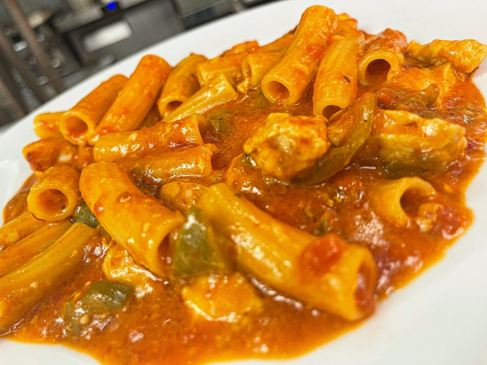
Chicken riggies from Chesterfield’s Tavolo, the Utica restaurant laying claim to the famous area dish (Chesterfield’s Tavolo).

Around the turn of the century, Italians made up a higher percentage of the Utica population than in New York City, Chicago, or Philadelphia, powering factories and construction in the rapidly industrializing city. Like Italian immigrants across the country, Utica-area transplants adapted many of their food habits to their new living contexts, growing produce in small backyard gardens and fermenting wine in basement cellars. The U.S. Food Administration’s attempts at forced culinary assimilation, often centered around arguments regarding nutrition and hygiene, largely went unheeded. As one public health reformer wrote, “people of this nationality… cling to their native dietary habits with extraordinary persistence.” With Italian immigrant communities resisting Americanization, the FA’s campaigns mainly served to entrench xenophobia among native-born populations.

As with the initial ostracization of Italian cuisine, its eventual acceptance by American society has decidedly political roots. When Italy joined the U.S. as an ally in World War One, Italian food was suddenly celebrated as a patriotic addition to the American diet. “Ravioli, favorite dish of our Italian ally, should be served on every American table,” read one 1918 Good Housekeeping article. Beyond serving as a symbol of wartime solidarity, Italian food culture was embraced for its thrift and reliance on vegetables, crucial culinary characteristics in times of rationing. As the 1918 Good Housekeeping article explained, “meatless days have no terror for our Italian friends.” American acceptance of Italian cooking surged again during the Great Depression, when stretching meat and preventing waste again became a necessity. 

While America warmed up to legume soups, ravioli with tomato sauce, and the people who made them, stateside Italian cuisine was undergoing its own transformation. Most Italians who came to the U.S. during the main wave of immigration came from the southern regions where families reserved pasta, dairy, and meat for special occasions. In the prosperity of post-war America, recent Italian immigrants celebrated their new societal and economic status by creating hybrid dishes with these “high-status” ingredients. National favorites like spaghetti and meatballs and Utica classics like Utica greens and chicken riggies permeated the American culinary lexicon as a cuisine entirely distinct from that found back on the peninsula. Despite the challenges, Italian-American cuisine became a mainstay and point of pride in American food culture from household dinner tables to restaurants, including those in Utica and its environs.

Utica Santa Rosalia 1Southern Italian traditions live on through Saint Mary of Mount Carmel Church and Santa Rosalia’s Feast, first celebrated in 1915 (Daily Sentinel). 

Over one hundred years after mass Italian settlement, immigration remains an integral part of Utica’s story. As Central New York industry collapsed and Utica’s population precipitously declined through the end of the twenty-first century, Bosnian refugees strengthened the city. In 2005, the United Nations High Commissioner for Refugees focused an issue of its magazine on Utica, calling it, “The Town That Loves Refugees.” In 2017, twenty-five percent of Utica’s population was estimated to be made up of refugees and their children. Later immigration from Vietnam and Russia, and more recently from Burma and Somalia, has continued to shape Utica’s revitalization—and culinary landscape.

Mersiha Omeragic opened Yummilicious after coming to Utica in 1994 as a Bosnian refugee. Bosnian bean soup sits adjacent to chicken riggies on the diverse and popular cafe menu (Utica-Observer Dispatch).

The immigrant experience in Utica vividly illustrates the ongoing process of leaving one home and establishing another, with food playing a pivotal role in this journey. The prevalence of Italian-American restaurants in Utica stands as a testament to a long history of resistance, adaptation, and eventual integration. Hybrid cuisines capture extended narratives of cultural negotiation, where food symbolizes cultural preservation, adaptation, and acceptance. This process of place-making in Utica continues with the arrival of new immigrant communities. Take the example of Yummilicious, a Bosnian-owned restaurant offering a range from waffles to meza, which is carving out a place in Utica’s culinary scene alongside established favorites like Delmonico’s and Chesterfield. The growing popularity of these more recently arrived immigrant cuisines suggests a more inclusive reception for new arrivals. This hopeful trajectory suggests that Utica’s culinary landscape will increasingly reflect the rich tapestry of its diverse community, continuously evolving as new flavors and traditions become recognized as integral to the city’s identity.

Guttman, Naomi, and Roberta l. Krueger. “Utica Greens: Central New York’s Italian-American Specialty.” Gastronomica 9, no. 3 (August, 2009): 63–67. https://doi.org/10.1525/gfc.2009.9.3.63.

Hartman, Susan. “How Utica Became a City Where Refugees Came to Rebuild.” Literary Hub, July 9, 2022. https://lithub.com/how-utica-became-a-city-where-refugees-came-to-rebuild/.

Haverford College. “Exploring the ‘Urban Colonies’ of Utica,” September 16, 2010. https://www.haverford.edu/college-communications/news/exploring-urban-colonies-utica.

Levenstein, Harvey. “The American Response to Italian Food, 1880–1930.” Food and Foodways 1, no. 1–2 (January 1, 1985): 1–23. https://doi.org/10.1080/07409710.1985.9961875.

Sullivan Borrelli, Katie, and Tracy Schuhmacher. “Utica’s Refugees Bring Transformation to Upstate NY.” Rochester Democrat and Chronicle, January 10, 2022. https://www.democratandchronicle.com/in-depth/news/2022/01/10/uticas-refugees-upstate-ny-transformation/8765746002/.

Utica: The Last Refuge. “Utica History.” Accessed September 9, 2024. https://www.lastrefugedocumentary.com/learn-more/history.

Utica University. “Ethnic Heritage Studies Center.” Accessed September 9, 2024. https://www.utica.edu/directory/ethnic-heritage-studies-center.

Too Much Migration, Too Little Integration: How Denmark is Trying to Destroy its “Parallel Societies”

By Maia Chakin

Denmark is known as a progressive socialist nation with a robust welfare system, yet this small, homogenous country does not serve all of its citizens equally. In the name of encouraging participation in Danish culture and reducing crime, the government has instituted a plan to eliminate the areas that it deems ghettos or “parallel societies” by 2030. This plan was originally put in place by right wing powers in 2018, yet, the center-left coalition currently in power has continued these policies while referring to the communities they are destroying as “parallel communities,” rather than ghettos. 

 Map of development plans for Denmark housing. Source: Politiken Grafik

The criteria for a neighborhood to be characterized as a ghetto/parallel society bluntly reveal the anti-immigrant sentiments behind this law. These neighborhoods must have at least half of the population is from non-western origin or descent (including both those who were not born in Denmark, and those who were born of immigrant parents) and at least two of the following characteristics: low income, low education rates, high unemployment rates or conviction rates of three times the national average. In areas that meet the above criteria, social housing levels need to be reduced to a maximum of 40 percent by 2030. A further statement by the Danish government in 2021 claimed that the goal of the parallel society policy was to reduce the percentage of people with non-Western backgrounds in a given residential area to 30 percent by 2030. Other elements of the government’s parallel societies initiative includes a policy requiring young children in areas deemed vulnerable to attend Danish preschool for at least 25 hours per week in order to learn the Danish language and values. 

Danish officials justify this policy by claiming a lack of integration and participation in Danish society from these immigrant populations. The government’s One Denmark without Parallel Societies report claimed that there were “holes” in Denmark’s map where citizens were not taking “sufficient responsibility” because they did not “actively participate in the Danish language, society, and labor market” or “embrace Danish norms and values.” The government seems to believe that these non-westerners are taking advantage of Denmark’s social welfare system without giving back to the country. This assimilationist rhetoric discounts the importance of Non-western cultures and villainizes some of Denmark’s most marginalized populations. 

A housing estate in Mjolnerparken, Copenhagen

The parallel societies plan is forcing largely non-western and non-white populations in Denmark out of their homes, which will be demolished and resold to wealthier (mostly non-immigrant) people. Although some people are fine with, or even happy about, being relocated to different neighborhoods, many residents are devastated to be forced out of places they have built their lives in. Mjølnerparken, a residential area in Copenhagen with one of the highest percentages of non-western residents, has faced extreme measures by the government, with some entire blocks of residents being forced-out. 

Some officials claim that these policies are being put in place in order to provide people living in these low-income enclaves with better opportunities, but how is forcing people out of their homes the best way to achieve this? A quote in the New York Times by a woman from a social housing organization in Denmark makes the desires of those who live in these parallel societies clear: “If they made the program voluntary, most people would like to stay. The experiment would have failed.”

Works Cited

Bubola, Emma. “Denmark Aims a Wrecking Ball at ‘non-Western’ Neighborhoods.” The New York Times, October 26, 2023. https://www.nytimes.com/2023/10/26/world/europe/denmark-housing.html?smid =nytcore-ios-share&referringSource=articleShare.

“How Denmark’s ‘ghetto List’ Is Ripping Apart Migrant Communities.” The Guardian, March 11, 2020. https://www.theguardian.com/world/2020/mar/11/how-denmarks-ghetto-list-is-ripping-apart-migrant-communities.

John, Tara, and Susanne Gargiulo. “Denmark Is a Liberal Paradise for Many People, but the Reality Is Very Different for Immigrants.” CNN, July 20, 2020. https://cnn.com/2020/07/20/europe/denmark-ghetto-relocation-intl/index.html.

Wenande, Christian. “Forget Parallel Societies: Is the Ghetto Plan Stuck in a Parallel Universe?” The Copenhagen Post, October 17, 2022. https://cphpost.dk/2022-10-22/news/forget-parallel-societies-is-the-ghetto-plan-stuck-in-a-parallel-universe/. 

Jersey City, the New Manhattan

By: Mattie Buneta

Hating on the great state of New Jersey, once every New Yorker’s favourite hobby, has become a national hobby. But New Yorkers, always ahead of national trends and eager to subvert cultural norms have begun to do the unthinkable, moving to the Garden State.


Perhaps that’s because New York has, since the rise of Jace Jacobs inspired acitvists, seeked to retain communities and cultures, leaving back the New York once known for erasing its history faster than it could be created. Focuses on retaining the culture of communities has resulted in many parts of the island not getting new affordable housing, and difficulties in building new high-rises. This is a legacy that has been taken on by New Jersey in its quest to fill-in the regional housing gap with “Hudson County overall [permitting] well over double the rate of housing that New York City does (51 units/10ks residents vs. 22 units/10k residents)”. This creation of housing may play some role in the fact that rents in Jersey City are both lower than other similarly gentrifying areas within the city proper, but that they are also increasing at a slower rate, making it more and more financially attainable.

And perhaps the rise of hybrid workers is also changing the finances of commuting. The perennial claim against New Jersey was that, while rent was cheaper the cost of commuting five days a week for work made the costs similar, if not the same. This math begins to tilt more and more towards New Jersey’s favor with lengthier commutes and commuting costs meaning less and less when individuals have to do it less often. This change to remote work can be seen with “Many of [Manhattan’s] offices are half empty, and its population is shrinking”. These offices are likely to remain closed should the trend of companies creating Satellite offices in Jersey City continue, such as those in the finance community, which have increasingly bought office spaces in Jersey since the 90’s.

And perhaps this commuting is getting less lengthy and more integrated, decreasing the physical boundaries within the spaces of New Jersey and causing the city to become increasingly compressed into the geography of New York City. Increased public transit options such as the rise of PATH trains weakens and blurs the boundaries between the two cities.

(Map of Routes on the Hudson-Bergen Light Rail)

This is particularly effective given its multiple locations within subway stations, which creates an effect wherein the transit becomes an effective extension of the existing transit infrastructure, rather than a separate entity unto itself. Outside of this the rise of social media has made it so that New Yorkers, only willing to travel to the Newark airport, are able to be exposed to Jersey City’s cultural amenities without having to commit to travel there, with the digital spaces of the two cities becoming increasingly interlinked. And perhaps New Jersey’s new cultural amenities (beginning to be tailored to the needs of the nouveau riche and replacing local communities) are working towards decreasing the stigma of the ‘bridge-and-tunnel crowd’ so well known for its inability to fit in with the New York elite. It houses artists priced out of Manhattan, and is beginning to weaponize them into getting a ‘cool’ factor leading Timeout NY to name it ‘one of the hippest places in the world’. Its new beer gardens and niche cocktail bars both serve this rise of newcomers, and encourages more to follow in their wake.

No matter the reason, Jersey City is becoming more Manhattan by the day, for better or worse.

Sources:
https://www.timeout.com/jersey-city/things-to-do/jersey-city-is-having-a-moment-and-you-should-go-there-asap
https://www.businessinsider.com/people-moving-from-nyc-too-expensive-to-jersey-city-2023-9
https://catalyst.independent.org/2022/10/12/jersey-city-new-york-borough/
https://www.ft.com/content/4796472e-59e7-48cd-a101-d2a8aac73132

My Experience as an Outsider in Dallas

In early June of last summer, I visited my friend, Sohan, who lives in Wylie, Texas, just outside of Dallas. We were best friends in high school, and he had moved to Texas after he graduated so he could live near where he was going to college. I hadn’t seen him in two years and was eager to catch up with him. What I never would have expected was the massive culture shock I experienced during my visit. I came to realize during my week in Dallas what people mean when they say “everything’s bigger in Texas” – everything is so spread out that living in and around the city necessitates owning a car as the primary means of transportation. 

I immediately noticed something was different about Dallas when I exited the Dallas/Fort Worth International Airport and got in my friend’s car. As we left for his house, we got on a highway called the “High Five Interchange,” a collection of roads swirling around each other and going above one another in ever increasing heights. Sohan described it as “like being on a roller coaster,” which I think was a good way to illustrate the insanity of the road system I found myself on. There was something fascinating about driving over and under all of these different roads, but it was just a taste of what was to come. I found that for the entirety of the trip, we were dependent on roads to get around. 

As we talked in the car for about an hour, we approached where he lived, a planned community called Inspiration. I was taken aback by everything about this place. To start, Inspiration is pretty much in the middle of nowhere, and it takes 40 minutes by car to get from Sohan’s house to where he goes to college, the University of Texas at Dallas. I live in Moorestown, New Jersey, and if an out-of-town friend was staying at my house, I would probably take a walk with them into the main part of town to visit some of the local shops. But when staying in Inspiration, we were completely isolated from the rest of the world without a car. James Adams with the American Institute of Architects in Dallas wrote about how “a ten-block walk to the grocery store, common in the early ‘50s, [has] all but vanished as our lifestyles morphed to accommodate the assumption that we must drive to our destinations,” which is something I can corroborate – walking anywhere in Dallas was an impossibility for us (Adams). Any time we wanted to go somewhere, we had to get in Sohan’s car and drive there, including if we wanted to go to other places in the Inspiration development. We rarely drove less than half an hour going from place to place, and I’d say most of the time it would take us an hour to get to our destination, especially if we were departing from Inspiration. Adams wrote how “sprawl has not only made us automobile-dependent, it has changed the organization of our neighborhoods and eroded our culture by chipping away at connectivity,” which I think reflects how out-of-the-way Inspiration is, and how that forces you to need to have a car to get anywhere (Adams). 

An aerial view of Inspiration. You can see how, even within Inspiration, the houses are spread out to the point that getting from one end to the other would require a car (Brightland Homes).

Another fascinating thing about Inspiration was its design, both internally and how it relates with the landscape surrounding it. Sohan said to me as we first passed by the big “Inspiration” sign at the neighborhood’s entrance that “Inspiration is like communities within a community,” which perfectly describes the organization of the development. Internally, Inspiration is set up as multiple villages that border each other to make up the overall Inspiration community, including subdivisions called Destiny, Hope, Discovery, Grace, Harmony, Faith, and where Sohan lives, Peace. On the outside though, Inspiration is surrounded by large expanses of farmland with a few rundown-looking houses and trailer parks scattered throughout. Sohan told me that the construction of Inspiration was controversial, as many of the farmers living in the area didn’t like the idea of having such a big community that would take up that much land. Many neighbors of Inspiration are still unhappy about its existence, and oppose any further expansion of the community onto more surrounding land.

A picture I took as we left Inspiration. The development is mostly surrounded by farmland and empty space (Socolow).

One final thing that was interesting to me about Inspiration was how similar all of the houses looked to one another. Every single house had the exact same gray-tiled roof, almost every house was made of brick, and they were all roughly the same size. This was similar across the different subdivisions as well – whether you lived in Destiny, Peace, Faith, or wherever, the houses all looked similar to each other. The houses of Inspiration also stand in stark contrast to the look of the surrounding houses, many of which had peeling paint and overall looked in much worse shape. The houses and trailer parks outside of Inspiration also had much more rural aspects to them, such as how I often saw horses and cows in the pastures of farms, dishes for satellite TV, and other such features that significantly differed from the suburban feel of the Inspiration houses.

A picture I took of Sohan’s backyard, showing the homogeneity of the style of the houses in Inspiration (Socolow).

I had a really good time visiting my friend in Dallas, but I found it ridiculous how spread out everything was. Needing to travel by car to go anywhere was absurd to me, as I’ve always been able to walk places in every other place I’ve ever lived or visited. However, my experience is just a small look into the immense urban sprawl in Dallas. In a 2023 study about American cities with the most undeveloped land, “Dallas led with a whopping 90,739 acres [of undeveloped land]… not to be outdone, Dallas’ sister city, Fort Worth, Texas, boasted 74,835 acres of undeveloped land” (Brown). It wasn’t just me who experienced this sprawl for a week – the residents of Dallas and its environs are experiencing this every day. 

A graph showing the cities with the most undeveloped land. Dallas and Fort Worth lead, reflecting my experience of visiting them both for a week and driving past farmland for hours to get places (Yardi Systems).

Works Cited:

Adams, James. “Mobility, Sprawl, and the Future of North Texas.” American Institute of Architects Dallas, 2023. https://www.aiadallas.org/v/columns-detail/Mobility-Sprawl-and-the-Future-of-North-Texas/i7/.

Brown, Steve. “Dallas Tops Cities with Room to Grow, Boasting 90,000 Acres of Vacant Land.” Dallas News, March 27, 2023. https://www.dallasnews.com/business/real-estate/2023/03/27/dallas-has-more-than-90000-acres-of-room-to-grow/

Sohan Vidiyala, text message to author, October 31, 2023.

Images Cited:

Brightland Homes. Inspiration Aerial Shot. 2023. Online photograph. https://www.brightlandhomes.com/new-homes/texas/dallas-fort-worth/community/Inspiration-108563.

Socolow, Stephen. Photograph in Inspiration Backyard. June 2023. Personal photograph.

Socolow, Stephen. Photograph Outside of Inspiration. June 2023. Personal photograph.

Wikipedia. High Five Interchange. 2007. Online photograph. https://commons.wikimedia.org/wiki/File:High_Five_Interchange.jpg.

Wikipedia. High Five. 2010. Online photograph. https://commons.wikimedia.org/wiki/File:High_Five.jpg.

Yardi Systems. Total Vacant Land Available. March 2023. Online Photograph. https://www.dallasnews.com/business/real-estate/2023/03/27/dallas-has-more-than-90000-acres-of-room-to-grow/.

The Story of Little Tokyo: How Ethnic Enclaves Turn Nostalgia into Placefounding

By Arielle Schultz

Among the standard Los Angeles streets saturated with mid-century modern, mission revival, and international style structures, a small district of just five city blocks stands out, characterized by a unique Japanese influence, setting it apart from the rest of the city. Little Tokyo is a historic Japanese commercial district nestled in the heart of Los Angeles: Downtown LA (“Little Tokyo Historic District” ). Little Tokyo, one of the three ‘Japantowns’ in the United States, offers a variety of restaurants and cafes specializing in Japanese cuisine, as well as stores offering Japanese goods. The buildings are adorned with distinctive Japanese roofing, and red and white circular lanterns are strung from one establishment to another. Despite Los Angeles being a multicultural and diverse city, Little Tokyo stands out as an anachronistic enclave with a culture and aesthetic that diverges from both Los Angeles and its namesake, Tokyo. 

The Japanese Village Plaza, a shopping complex located in Little Tokyo. (Photo: California.com)

While hordes of tourists and locals may flock to the bustling streets of Little Tokyo for a chance to capture a quick photo or snag a souvenir that provides a taste of Asia without the long flight or the expensive ticket, many remain unaware of the intriguing history behind Little Tokyo’s distinctive blend of American and Japanese influences. The origins of Little Tokyo can be traced back, in part, to the aftermath of the Chinese Exclusion Act of 1882 (“Little Tokyo Historic District”). Following the decline of Chinese laborers, Japanese workers gained increased importance to American businesses, resulting in a rapid influx of Japanese immigrants in cities along the West Coast. Los Angeles, in particular, became a focal point in 1884 when Hamanosuke Shigeta, a retired sailor and one of about 70 Japanese residents, opened the doors to his restaurant. This marked a milestone as the first Japanese-owned business in the city and is considered the pivotal moment known as the “Birth of Little Tokyo” (“LA Honors”). After decades of growth, by 1942, Little Tokyo cemented itself as a vibrant community with more than 35,000 members working and living there. 

While Little Tokyo sought to emulate the cultural and architectural aspects of their home place, it was impossible to prevent elements of standard American life from seeping into their enclave. The prosperity of Little Tokyo faced severe setbacks following the bombing of Pearl Harbor, as the United States retaliated with Executive Order 9066, fueled by hysteria and distrust toward Japanese-Americans. This executive order compelled 120,000 people of Japanese descent to relocate away from the West Coast (“Little Tokyo Historic District”). Consequently, this act of tyranny turned Little Tokyo into a virtual ghost town. Because of these newfound vacancies and the racial segregation that ostracized Black residents from many other neighborhoods, African-American families started to inhabit what used to be Little Tokyo, briefly converting the district into a Black enclave penned Bronzeville until the end of World War II (Florido 2017). 

Even as Japanese Americans returned to Little Tokyo, rekindling its Japanese influence, many Black Americans continued to reside in the district and coexist with the Japanese residents. The establishment of the Common Ground Committee aimed to cultivate positive interracial relations, and Japanese businesses that successfully renewed their leases actively employed the new Black residents, and reciprocally, Black-owned businesses hired Japanese residents (“Little Tokyo Historic District”). Even though Bronzeville no longer exists, according to the 2010 Census, Little Tokyo is still 25.9 percent Black American, highlighting how this ethnic enclave has adapted to its surrounding demographics (Painter 2015, 1). 

Japanese residents of Little Tokyo preparing to evacuate in 1942. (Photo: LAMag)

If one strolls through the blocks of Little Tokyo today, the distinct fusion of Japanese and mainstream American culture remains the defining characteristic of the place. A business that perfectly captures this multicultural identity is Japangeles. Not only does its name serve as a symbolic representation of Little Tokyo’s American influence, but numerous clothing products on display feature traditional Japanese aesthetics but are presented in English lettering, showcasing the process of Americanization within Japanese culture.

However, Little Tokyo is not the sole example of this distinctive cultural amalgamation. Countless cities across the United States and worldwide have areas designed to replicate the ancestral home place of a specific minority group. For example, São Paulo, Brazil, is home to their own Japantown, known as Liberdade, and there is also Little Havana, a neighborhood inside Miami. As time passes, these spaces have all evolved into entirely new places that blend elements of the surrounding mainstream culture with the heritage of the given immigrant group. These places of cultural fusion can provide a safe haven for immigrants struggling with homesickness, nostalgia, and root shock and offer a less jarring path to acclimatization in an unfamiliar land. 

A mural in Little Havana, a historically Cuban neighborhood in Miami, FL. (Photo: Alamy)

That being said, the authenticity of these ethnic enclaves’ culture can be threatened through the process of gentrification. This transformation often occurs when the place in question flourishes and becomes sought out by people who earn a higher income with a “desire for an authentic urban experience” (Zukin 2010, 4). Sharon Zukin defines authenticity as the “expectation that neighbors and buildings that are here today will be here tomorrow” (Zukin 2010, 6). The gentrifiers who search for authenticity are ironically compromising the place’s continuity, and therefore authenticity, by pushing out long-term residents due to the rising cost of living and property values.

Circling back to Little Tokyo, its residents are confronting the concrete consequences of gentrification due to a surge in interest in Japanese culture and the subsequent commodification of Little Tokyo’s authenticity (Anabel 2022). As demonstrated by the earlier example of Japangeles, there are already businesses capitalizing on Little Tokyo’s distinctive and multicultural identity. Locals express their worry that this new business environment and the rising rents are starting to erase the established culture cultivated by the original shop owners of Little Tokyo, who had settled in the town 135 years ago. 

As we reflect on the story of Little Tokyo and ethnic enclaves similar to it, it is essential to remember to safeguard the authenticity and heritage of these communities while simultaneously appreciating their unique cultural offerings. We must support policies that preserve the unique character of these neighborhoods, ensuring that they remain culturally rich while also avoiding the disastrous effects of gentrification. Our actions can help protect the very essence that makes these places so unique as well as preserve their legacy for future generations to serve as a reminder of the beauty that multiculturalism produces. 

Works Cited:

Anabel. “Little Tokyo: A Community of Fading Tradition.” High School Insider, August 5, 2022. https://highschool.latimes.com/university-high-school-2/little-tokyo-a-community-of-fading-tradition/.

Florido, Adrian. “How ‘little Tokyo’ of Los Angeles Changed into ‘Bronzeville’ and Back Again.” NPR, February 19, 2017. https://www.npr.org/2017/02/19/516064700/how-little-tokyo-of-los-angeles-changed-into-bronzeville-and-back-again.

“LA Honors Former Restaurant as First Japanese-Owned Business in Little Tokyo.” MyNewsLA.com, January 12, 2022. https://mynewsla.com/business/2022/01/12/la-honors-former-restaurant-as-first-japanese-owned-business-in-little-tokyo/.

“Little Tokyo Historic District.” National Parks Service, October 12, 2023. https://www.nps.gov/places/little-tokyo-historic-district.htm#:~:text=Little%20Tokyo%20Historic%20District%20is,community%20in%20the%20United%20States.

Painter, Gary, Jung Hyon Choi, and Vincent Reina. “Little Tokyo Community Assessment.” Sol Price Center for Social Innovation, 2015. https://socialinnovation.usc.edu/files/2013/01/Little-Tokyo-Community-Assessment-093016-Final_with-description.pdf.

The Rock Crusher: Through a Local’s Eyes

By Jess Parsons

On July 2nd, 1918, a TNT plant in Syracuse, NY exploded. 50 people died and countless others suffered permanent injuries. Originally, the plant was a limestone quarry, but it transformed into a munitions factory during World War I and became one of only 18 suppliers of artillery shells for American troops. After the disaster, it was abandoned. Today, all that remains is the original, 75-feet-tall, limestone rock crusher.

Known solely as “The Rock Crusher,” explorers from all over Central New York visit this 1,000 acre site. Some come looking for the tunnels thought to be haunted by those killed in the explosion, while others prefer to hike the endless desire paths formed by mountain bikers, runners, and walkers. Though some locals frequent this site to enjoy its natural beauty, many are deterred not only by its history but its eerie seclusion.

Close by, there are neighborhoods full of middle-class families who are thankful to live near a unique historical site. Many residents walk their dogs on its trails, and the local police and firemen once had their own shooting range and a designated area for target practice (an interesting fact to examine with its militaristic history). However, it is most notorious for partying.

For generations (since the 1970s, if not earlier), young adults and teenagers used The Rock Crusher to party and called it their own. Contrary to what one may assume, the gatherings here were intimate, consisting of small bonfires with friends rather than big local blowouts. According to an interviewee, those who found solace here were typically neighborhood kids with rougher home lives and less restrictions because of the freedom it provided. Its remote location prevented police from frequenting often, so friends drank, smoked, and graffitied in peace. Thus, around 8pm each weekend, small friend groups would flock here to let loose until about 1 or 2am.

Syracuse experienced a heroin and fentanyl crisis in 2016, and grungier white suburban youth were most susceptible. The kids who frequented the Rock Crusher were those who were affected. Its lack of surveillance attracted dealers, and the space became one riddled with paraphernalia. As the epidemic spread, the Crusher and its identity suffered. Heartbreakingly so, I remember the police were called to the dead end more and more often as overdoses spiked. Tourists still visited during the day, but at night, it was no place to go.

Around 2017, surveillance cameras were installed, and the partying and drug-use dispersed. There have been a few cases of individuals going missing since then, but otherwise, the Crusher is mostly peaceful.

Today, there are efforts to preserve the Rock Crusher as a historical site. Whether or not these initiatives succeed will depend on the community’s resolve to maintain the Crusher as a safe space for visitors. As seen on reddit, the Crusher holds a place in many people’s hearts and will continue to do so for decades.

A Divided Delmar Turns Divine? A Story in Reversing Harmful Urban Policy

By Ethan Kalishman

Sometimes, it is hard to conjure positive ideas about St. Louis, Missouri – that is, beyond the fact that both I and Budweiser were created there. Jokes aside, St. Louis has a rich, yet complex history that has continually generated reverberations around the world, from the Dredd Scott court decision to Ferguson’s Police Shooting of Michael Brown and 2020 BLM protests. Naturally, the media and nation may perceive the city as a haven for crime, murder, and racial strife. MSNBC, for example, has published an article as recent as a week ago saying that “With an alarming 69.4 percent murder rate, St. Louis holds the unenviable position as the most dangerous city in the United States. Countless residents report urban decay, badly-damaged roads, drug use, and an unhoused population spiraling out of control as to why murder rates are so high. To make matters worse, local officials seemingly have no idea how to fix things.” However, I believe that the challenges that establish St. Louis as a prime case study of policy failure create a deep bond among St. Louisans. After all, the St. Louis Cardinals finished second in highest attendance for the MLB in 2022, drawing 3.32 million fans. Somehow, I am just as proud to be a product of Missouri as I am also weary of our faults. I hope to demonstrate this sense of resiliency by depicting the long story of the Delmar Divide.

In class, we read from Richard Rothstein’s story of St. Louis, which powerfully depicted St. Louis and Ferguson as a prime subject of the area’s color of law and racial discrimination. A lot of his claims rang true with my own life experiences. For example, Rothstein described the suburbs I have grown up in that I see myself as segregated because of redlining, housing covenants, and other localized racial restrictions. However, Rothstein did not capture every story of St. Louis’ difficult and harmful discrimination and I think it is essential to extend his study onto Delmar Boulevard’s disparity to better understand the city’s oppressive urban policy.

The Delmar Divide is a term labeled for Delmar Boulevard’s stark socioeconomic and racial division between either side of the major east-west street in St. Louis. As the BBC reports, to the North of Delmar, the median home value is $73,000, the median household income is $18,000, 10% of the population has a bachelor’s degree, and 98% of the population is Black. These facts are contrasted by the South of Delmar, where the median home value is $335,000, the median household income is $50,000, 70% of the population has a bachelor’s degree, and 73% of the population is white.  As a result, schools in the northern neighborhoods receive 30% less funding per student compared to those in the south, leading to disparities in academic performance. This segregation can be further reflected in cancer outcomes, as communities north of Delmar hold higher rates of breast cancer. In fact, Black women north of Delmar are more likely to be diagnosed with later stages of breast cancer with a mortality rate 10% higher than the total population, since these women are more likely to delay diagnosis and treatment due to cost. While there are many other facts of disparity, it thus should be clear that this divide powerfully stands.

Delmar’s gap of equality is historically rooted in redlining practices, which limited access to loans and resources for Black communities. This divide importantly did not happen overnight. As Darian Wigfall, activist, artist, and filmmaker says on a Now This segment “the racial divide here is a hangover from the history we have.” Next City Magazine also describes the Delmar Divide as an intentional phenomenon: “In the early 20th century,” it writes, “as former enslaved persons and their descendants began to escape the Jim Crow south during the Great Migration, the white-controlled St. Louis real estate industry employed a system of racial covenants and steering to drive the city’s growing black population to neighborhoods north of Delmar, while driving white families to the south.” Later, between 1934 and 1962, the FHA insured $120 billion in home mortgages, with 98% going to white borrowers. As a result, nonwhite populations couldn’t make necessary repairs to their homes, and the next generation of buyers were also precluded from taking over from predecessors. While the Fair Housing Act was passed in 1968, which ended explicit redlining, it was too late for homes north of Delmar. After decades of being denied the capital to keep homes livable, homeowners simply walked away to suburban life. Illustrating it is the fact that St. Louis had a peak population of nearly 860,000 in the 1950s and today it’s just 319,000. It’s a steeper decline than any of the former industrial powerhouses known as “Legacy Cities.” That’s one reason why when I and my peers say I am from St. Louis, we mean that we are from St. Louis County, not St. Louis City. I myself am a product of the city’s redlining, living in a white suburb. And yet, that does not mean the region’s fate is sealed or doomed.

Maxine Clark, affectionately known as the founder of Build-a-Bear Workshop, derived an idea to bridge both sides of Delmar with a $100 million rehabilitation of St. Luke’s Hospital. Calling her project “Delmar DivINE,” she aimed to “redefine the West End neighborhood, beginning to replace decades of neglect with innovation, development and sustainability.” Consisting of a 150-unit, 8-story apartment building, the 2021 mixed-use project includes affordable modern apartments, offices, a café and a nonprofit collaborative aimed to support over 20 local agencies combatting injustice. Delmar DivINE’s funding comes from a public-private partnership that ironically includes FHA insurance on the loan, but also new market and historic tax credits, as well as donations toward the nonprofit collaborative. Of course, the facility is not an end-all-be-all solution to the horrors of the Delmar Divide, but it is a powerful marker of admission of the issue surrounding the Delmar Divide and better yet, a positive force that will resist the power of the current divide. Delmar DivINE shows that as much as harmful policy has shaped horrible inequalities, our cities are not beyond hope. We can at least begin to reverse these situations with collective action.

Indigenous Border Crossing Rights between the United States and Canada

By Val Laurianti (she/hers)

Map of Indigenous Nations pre-colonialization from VividMaps

The boundaries drawn that make up the United States are the result of years of colonialism, violent conflict, and legal frameworks that privileged concepts of manifest destiny and Lockian ideas of private property. Coerced, illegitimately, and broken signed treaties with indigenous nations are a part of how the United States bounds its territory. Borders, by nature, create zones of exclusion and inclusion. Yet echoing the activist phrase of “no one is illegal on stolen land”, the right of the federal government to determine who is allowed to occupy and move in and out of its borders is lacking in legitimacy. Immigration discourse in the United States often tends to be dominated by discussion of the U.S.-Mexico border and is heavily racialized. Yet, there is another salient question of immigration rights, race, and the legitimacy of colonial boundary maintenance at the U.S.-Canada border. 

For indigenous nations, their land claims predate, transcend, and do not conform to colonial borders, meaning there are many nations that exist across both sides of the land now called Canada and the United States. Political, cultural, familial, spiritual, social, and economic processes happen across these imposed international lines. Thus, it is an important right for indigenous people whose nations are split by colonial borders to be able to live their lives fluidly across them. It is also a right recognized by the United States and Canada through the Jay Treaty, which was signed in 1794 and granted indigenous peoples both free passage and duty-free transportation of goods. The duty-free goods agreement is no longer implemented

Newer legislation further restricts border passage rights via colonial knowledge production about race. The United States Immigration and Nationality Act created a policy in which a person needs to legally prove they have at least 50% “American Indian Blood”, to be allowed free entry and egress. Additionally, only certain communities count as “federally recognized tribes”, and are able to access border passage rights. Not meeting the legal bounds of blood quantum clearly doesn’t mean that the person doesn’t have an identity and experience of being indigenous. Many indigenous nations also welcomed people into their communities, particularly black people who recently were freed or escaped from slavery. Descendants of these individuals may face hardship in being able to meet blood quantum standards. Those whose historical records of ancestors have been lost, which could include those who were forcibly disconnected from their communities during the Sixties Scoop, would also be unable to meet quantum policy. 

This not only presents a disturbing asocial and eugenicist construction of race but also is inconsistent with how many nations and tribes self-determine membership. Over 70% of nations and tribes do use various percentages of blood quantum for self-determination of their membership lists, but others use different methodologies, including lineal descent. As generations continue down the line, fewer and fewer indigenous people will be able to access their rights of passage under current blood quantum practices. This legal erasure of identity and violation of rights and sovereignty falls under the continued cultural genocide facing indigenous peoples across the world. 

There are ongoing protests and resistance to blood quantum policies, with most advocates arguing that each tribe be allowed to individually determine how they want to allocate membership. Self-determination recognizes tribal sovereignty and allows for decolonial work around identity construction. In 2018, a bill was proposed in the House to relax blood quantum requirements, but it never came to a vote.

Ensuring indigenous people can access their land claims and the right of free and fluid passage across the U.S.-Canada border is both a legal and moral issue. Legally, removing blood quantum is a very important aspect of the government taking responsibility for past treaty agreements. It is also essential to the continued preservation of indigenous places and communities. Furthermore, the conflicts that arise out of the concept of indigenous free passage rights is an entry point into broader critiques of what purposes borders serve, what harmful structures they may uphold, and how settler colonialism continues to have a pervasive effect on both policy and people’s daily lives.

The Mighty Moraine: The Relationship between Topography and Development on Long Island

By Nate Cohen

Physical geography dictates so much about place. For any given place, the physical landscape can drastically affect migration patterns, economic development, environmental conservation, and weather. It also frequently dictates the density, class, and racial composition of an area. In this blog post, I will examine the intersection of physical and human geography in my home region, Long Island.

Across both of its counties, Long Island is highly segregated. Indeed, among similar-sized counties, the 2010 census ranked Nassau County as the most segregated (Winslow 2019). Using the same metric, Suffolk County was ranked the 10th most segregated nationally (Winslow 2019). Interestingly, segregation patterns closely track the physical geography of the region. Below, is a topographic and satellite map of Western Long Island.

Produced by Dr. J. Bret Bennington
Hofstra University
Department of Geology

Source: Google Maps

The topographic map illustrates the Harbor Hill Moraine, the chain of hills roughly demarcating the North Shore region. Now, compare this to the satellite map. As you can see, there is a development divide that roughly follows the moraine. North of the moraine, there is a lot of greenery. South of the moraine, there is more dense development. 

Geography may help explain this different development pattern. North of the moraine, there are a variety of peninsulas of higher elevation, 200 to 300 ft above sea level. These elevations drop rapidly to meet sea level at the Long Island Sound, making the area hilly. These hills, combined with the lack of geographic continuity, hinder urban sprawl. Moreover, its isolation, and waterfront access, make the North Shore an alluring place for the wealthy.

While water serves as a barrier to roadway development and urban sprawl on North Shore peninsulas, the continuity of land south of the moraine facilitates such development. In turn, the greater abundance of noisy, polluting highways and cheap, dense housing renders the area less attractive for the wealthy. 

The satellite photos below illustrate the stark difference in development for two communities on opposite side of the moraine. The first photo shows the Village of Hempstead. Located in the flat, continuous region south of the moraine, the village is dominated by dense developments, parking lots, parkways, and boulevards. In Hempstead, the population is 13% White, with a median household income of $74,680 (“Hempstead Village”). By contrast, the second photo shows the Village of Sands Point. At the tip of the hilly Cow Neck peninsula, this village is characterized by winding roads, water vistas, spacious properties, and a large nature preserve. The population is 87% White, with a median household income of more than $250,000 (“2021 ACS: Median Income” ; “2021 ACS: Demographics”).

Google Maps: Village of Hempstead, NY
Google Maps: Village of Sands Point, NY

While the differences between these municipalities are extreme, they are not exceptional. Census data confirms the radically higher affluence of most North Shore communities. Located entirely south of the moraine, households in the Town of Hempstead earn approximately $15,000 less than the neighboring North Shore towns of North Hempstead and Huntington (“Hempstead Town”; “North Hempstead Town”; “Huntington Town”). 

Census data also confirms how patterns of development and racial geography are split by the island’s topography. For the wealthier, hillier, and waterfront town of Huntington, the population density is 2,170.7 people/mile (“Huntington Town”). Moreover, the town has a minuscule Black population, representing just 4% of Huntington (“Huntington Town”). By contrast, the flat and contiguous town of Hempstead has over triple the density, 6,694.7 people/mile, and quadruple the percentage of Blacks, comprising 17.3% of the population (“Huntington Town”). These disparities are summarized by the maps below (“Historic Census”).

Google Maps: Population Density by Municipality
Google Maps: Black Population by Municipality

As a caveat, while I believe physical geography helped produced these disparities, I do not for certain. This finding is not grounded in peer-reviewed research, but observations from maps and census data as well as my personal experience. Yet, given the clear geographic patterns of my observations, I suspect a more formal study would confirm my hypothesis.

Moreover, there is some ambiguity to the moraine’s demographic divisions. Garden City is an affluent, White suburb, yet it is located south of the moraine. However, this does not so much disprove my theory, as clarify it. While there are some affluent communities south of the moraine, there are also some poor areas. By contrast, there are virtually no poor areas on the North Shore

Overall, I hope this blog calls attention to how physical geography produces unequal development. In discussions of social and racial justice, this factor is too often overlooked. To attain a more complete understanding of racial and economic segregation, we should always investigate the role of the physical landscape.

Let Them Stay! A Case Against Defavelization

by Rafael Coutinho Padua

Growing up in Rio de Janeiro, the Cruzada São Sebastião always intrigued me. It is a yellow and red housing project situated at the intersection of the two most affluent neighborhoods in the city – Leblon and Ipanema. The centrally planned modernist buildings are in a much worse condition than the country clubs and shopping malls adjacent to it. In an attempt to understand the history behind this urban planning wildcard and whether it was a successful project, I will explain and then analyze the history of the community, while also showing how drastic government changes in place result in negative psychological effects in the populace.

The Cruzada São Sebastião is between Leblon (top right), Ipanema (top left). Below the buildings you can see Paissandu Atlético Clube, a traditionally British country club

The Cruzada São Sebastião is between Leblon (top right), Ipanema (top left). Below the buildings you can see Paissandu Atlético Clube, a traditionally British country club

Our story begins about 10 minutes away from Cruzada, in the extinguished favela of Praia do Pinto. This settlement was home to about 20,000 people, in the upscale neighborhood of Lagoa. Perhaps because of its strategic location in the Rodrigo de Freitas Lagoon, this favela attracted government planners to begin their plan to defavelize the city. As much as the intentions behind the project may have been good, it will become clear that there are downsides. I attribute the negative side of this change to two predominant factors – the nature of drastic and centralized changes in urban planning and the poor governance of the Military Dictatorship in Brazil, which was in its early years when the process of defavelization started.

The Military Regime in Brazil, like that of many of its South American neighbors, was a violent one. The Praia do Pinto community was a clear victim of this. It is widely accepted that the favela was set on fire by the government in an effort to accelerate the process of the community’s relocation to Cruzada. Because of the aggressive nature of this change and the lack of checks and balances typical in a Military dictatorship, not everyone was granted housing and those who did still struggled to adapt.

This image shows the fire in Praia do Pinto. The caption says that the wind nullified the Firefighter's efforts to reduce the fire.

This image shows the fire in Praia do Pinto. The caption says that the wind nullified the Firefighter’s efforts to reduce the fire.

The ‘luckiest’ inhabitants of Praia do Pinto were given an apartment in Cruzada. However, they still had to adapt to their new lives, now with toilets, sinks and a sewage system at their disposal instead of the collective tap and the porta-potty that most inhabitants were used to. In a TV interview, Maria Regina dos Santos, one of the many people who were forced into a new apartment, remembers her family struggles to learn how to use toilets and the sink, highlighting the friction she witnessed when relocating (WikiFavelas). Júlio César, a soccer player who also was forced into the Cruzada, argued that he was negatively affected by his relocation in a different interview (docsluciodecastro). While crying, he claims that moving into Cruzada was one of the many instances where life punched him in the face (docsluciodecastro).

Both of these examples show that humans can struggle with sudden changes caused by central government planning, and this causes negative psychological effects. Both Júlio César and Maria were victims of Root Shock, defined as a traumatic stress reaction to the destruction of one’s emotional ecosystem (Fullilove). If the experiences of people who were forced to move into Cruzada were sufficient in showing the injustices caused by the defavelization plan, the experience of those relocated to distant favelas shifts the concept of environmental injustice up a gear. An example of that is the experience of Tony Barro, a photographer who was forced from Praia do Pinto to Cidade de Deus. Tony explains that he was “almost thrown” from one favela to another, and that Cidade de Deus felt to him like “another world” (TV Brasil) Cidade de Deus, the favela portrayed in the film City of God, was isolated from the rest of the city, scarce in resources, and extremely violent.

Child gets hair cut in the recently built Cidade de Deus.

Child gets hair cut in the recently built Cidade de Deus.

As we can see, the Cruzada was the product of an unsuccessful and violent government effort to get rid of favelas. While some may argue that the move from Praia do Pinto to the modernist project of Cruzada was an infrastructural ‘upgrade,’ it is hard to deny the negative psychological effects of this change. Tony and Maria likely share their experiences with other victims of defavelization, a process where violent governance met the unpleasant frictions of change and created another outbreak of Root Shock in the Southern Hemisphere.

Works Cited:

docsluciodecastro. “Cruzada São Sebastião – Lúcio de Castro – Parte 2 de 5.” YouTube video, [11:26. December 19, 2011”. Accessed October 17, 2023. https://www.youtube.com/watch?v=Tb2Q_8opCy8&t=575s .

Fullilove, Mindy Thompson. Root Shock: How Tearing Up City Neighborhoods Hurts America, And What We Can Do About It. NYU Press, 2016. https://doi.org/10.2307/j.ctt21pxmmc.

TV Brasil. “Remoção da Favela da Praia do Pinto (1/4) – De Lá Pra Cá – 11/05/2009.” YouTube video, 10:02. June 2, 2009. Accessed October 17, 2023.[https://www.youtube.com/watch?v=JwWcfPC6isw].

WikiFavelas. “Favela Cruzada São Sebastião.” Accessed October 17, 2023. https://wikifavelas.com.br/index.php/Favela_Cruzada_S%C3%A3o_Sebasti%C3%A3o.

css.php